🥾 Trail guide · England – Yorkshire Dales
Malham Cove Walk via Janet's Foss & Gordale Scar: A Complete Guide to the Yorkshire Dales Classic

- Distance
- 8 km
- Ascent
- 230 m
- Time
- 2.5–3.5 hours
- Difficulty
- Moderate
- Route
- Circular
- Best season
- April–October
👶 With kids: The full loop isn't pushchair-friendly (stiles, rough fields, limestone pavement and around 400 steps), but it's great for kids 5+ on foot or in a carrier. The flat paths to the foot of Malham Cove and to Gordale Scar suit all-terrain pushchairs in dry weather.
✅ Updated and fact-checked on 2 November 2026. Prices, timetables and rules can change, so check the official sources before you go.
This post contains affiliate links. If you book or buy through them, I may earn a small commission at no extra cost to you. More about this
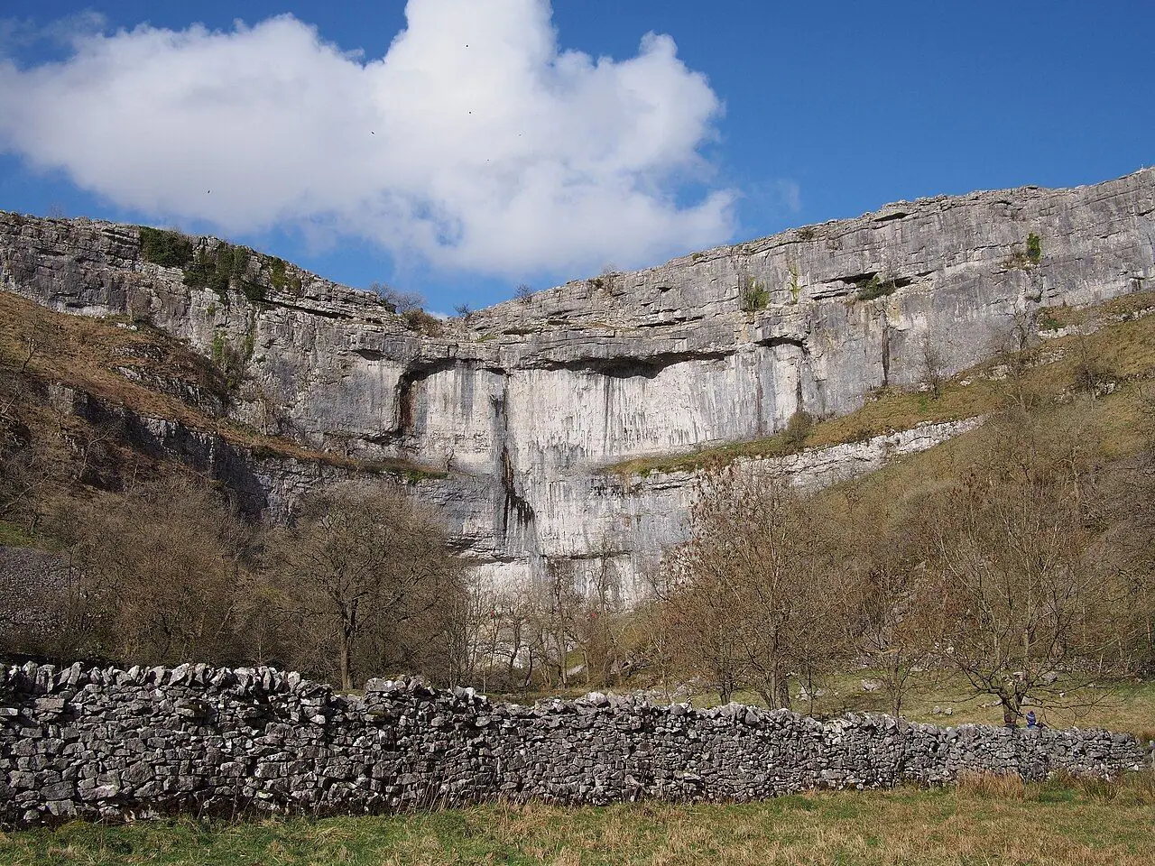
How about three famous natural landmarks in one walk? This circular walk from Malham links them with green fields, drystone walls and little streams. First comes Janet's Foss, a pretty waterfall falling into a jade-green pool in a wood that smells of wild garlic. Then Gordale Scar, a gorge so deep and overhanging that it feels like walking into a cathedral. Finally, Malham Cove: a curving 80-metre limestone cliff, with a huge cracked limestone pavement on top that looks like another planet.
We haven't done this walk ourselves yet, but it is high on our bucket list, so I've researched every detail for you.
All three were shaped by the Middle Craven Fault and by glacial meltwater at the end of the last Ice Age. Malham Cove was once a giant waterfall more than 300 metres wide! Gordale Scar was carved by meltwater cutting down along faults in the rock. Artists have been coming here for centuries. James Ward's enormous 1814 painting of Gordale Scar hangs in Tate Britain, and Wordsworth wrote a sonnet about it. Harry Potter fans might also recognise the pavement above the Cove, as it was a filming location for Harry Potter and the Deathly Hallows – Part 1.
The best part? It is around 8 km with no big summit, so it is a really achievable half-day walk. Also, you can get to Malham by bus on most days of the week, and there is lots to keep children interested. Below you will find the whole circuit, plus buses, parking and an easy way round the Gordale Scar scramble.
At a glance
- Distance: about 7.5–9 km, depending on detours (roughly 8 km for the standard loop).
- Elevation gain: around 230 m.
- Allow 2.5–3.5 hours, plus stops.
- Difficulty: Moderate. There are mostly good paths, but also some steep sections, rocky ground, uneven limestone pavement and a long flight of stone steps.
- Route type: Circular.
- Start/finish: Malham National Park Centre car park, Malham, BD23 4DA (grid ref SD 900 627).
- Best season: April–October. Spring is best for wild garlic at Janet's Foss and peregrines at the Cove.
- Prices: free to walk. Parking at the National Park Centre is pay and display.
- Toilets: at the National Park Centre (including an accessible RADAR toilet). There are pubs, cafés and tearooms in Malham, and a seasonal refreshment van often parks near Gordale Scar.
- Suitable for children: yes, on foot or in a carrier. However, the full loop isn't pushchair-friendly.
- Dogs: welcome, but keep them on a short lead near livestock and during ground-nesting bird season (1 March–31 July).
Route description
Most people walk the loop anticlockwise: Janet's Foss, Gordale Scar, then Malham Cove. I recommend this direction too. It saves the Cove for last, and you go down the long flight of steps beside it rather than up!
Malham to Janet's Foss (about 2.5 km)
From the National Park Centre, walk into the village and cross Malham Beck by the small bridge (there is an old stone clapper bridge too). Turn right onto the Pennine Way heading downstream. Then branch left on the signed path to Janet's Foss. The path follows a wall and Gordale Beck across fields, through a series of gates.
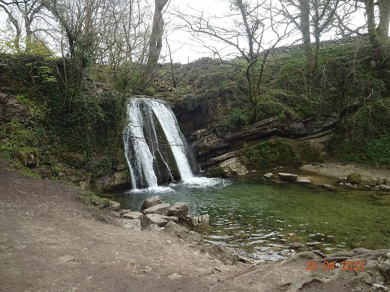
Soon you enter a National Trust woodland, which is carpeted with wild garlic in spring. The path brings you to Janet's Foss. Here Gordale Beck pours over a lip of tufa (a soft rock built up from dissolved limestone) into a deep pool. According to local legend, Janet, or Jennet, was a fairy queen who lived in a cave behind the falls. Farmers also traditionally used the pool for sheep dipping.
Janet's Foss to Gordale Scar (about 1 km)
Climb the rocky path to the left of the waterfall to reach Gordale Lane. Turn right along the road, past Gordale Bridge, and at the bend go through the gate on the left. Follow the clear path through the campsite towards the cliffs.
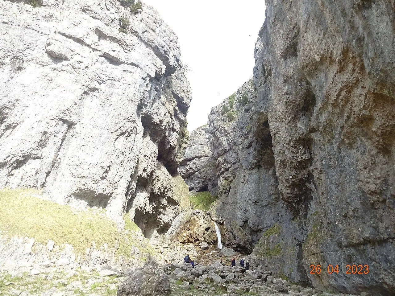
As you walk in, the walls of Gordale Scar close around you. The overhanging limestone cliffs rise more than 100 metres, until you reach the waterfalls at the end of the gorge. It is a really impressive spot, so take your time here.
Gordale Scar to Malham Cove (about 2.5 km)
The traditional right of way goes straight up the lower waterfall in Gordale Scar. Avoid this! It involves a scramble of several metres up wet, slippery tufa. The National Park asks walkers not to use it, because climbing damages the fragile tufa. It is also unsafe when the beck is high or icy.
Instead, go back out of the gorge to the road and turn right. Just past Gordale Bridge, go through the gate on the left, signed for Malham Cove. A path climbs the hillside beside a wall, through fields and gates. It is steep in places, but grassy and easy to follow. It takes you onto the open limestone upland. Cross a ladder stile by the road and continue on the grassy path. At the signpost, turn left for Malham Cove. Straight on leads to Malham Tarn, a longer option.
Limestone pavement and Malham Cove
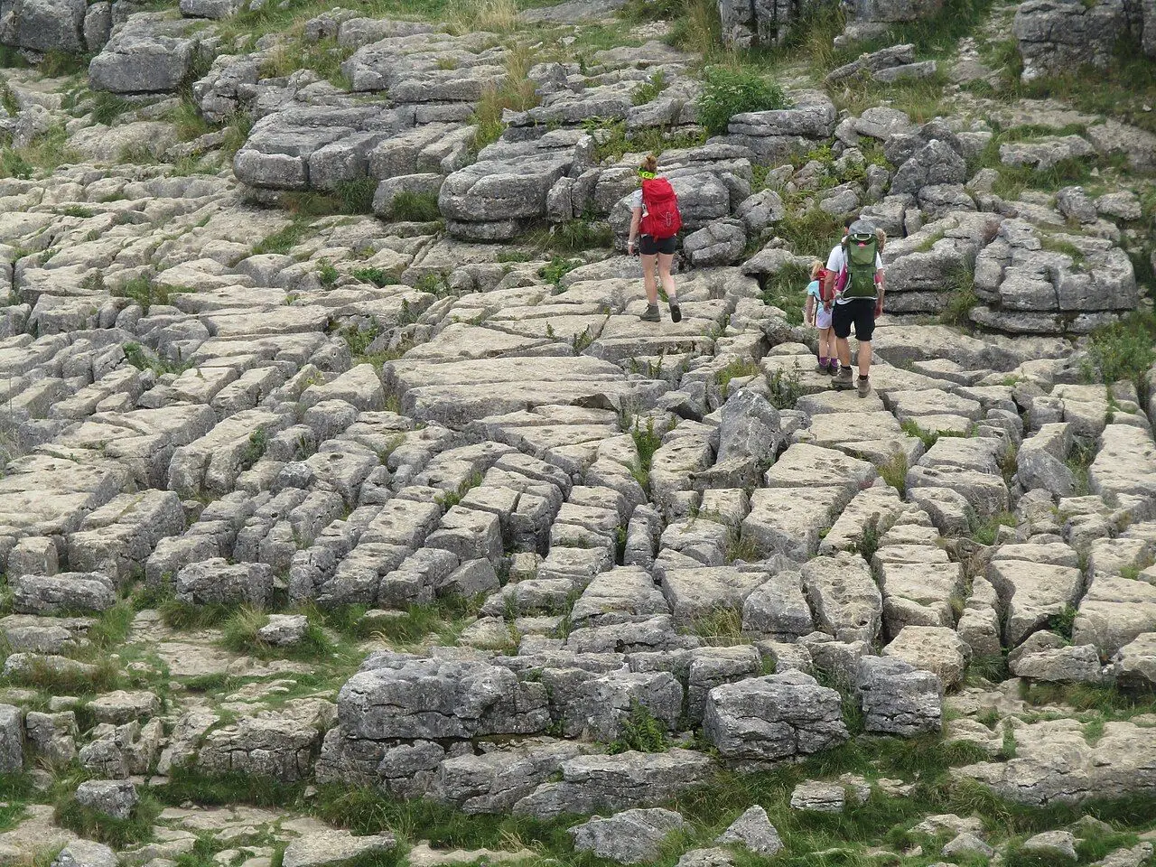
You arrive at the top of Malham Cove on its famous limestone pavement. It is made of grey blocks (clints) with deep cracks between them (grykes), where ferns and woodland plants shelter. Walk across carefully, as the gaps are deep enough to twist an ankle and the rock is slippery when wet. Also, keep well back from the cliff edge, which is unfenced. Parts of the clifftop may be roped off in nesting season to protect the peregrine falcons.
At the western end of the pavement, go through the gap in the wall. Then go down the long flight of around 400 uneven stone steps (part of the Pennine Way) beside the Cove. At the bottom, I suggest a short detour to the right to stand beneath the cliff face. It is even more impressive from below!
Malham Cove to Malham (about 1.5 km)
Follow the well-made path along Malham Beck back across the fields to Cove Road. Then turn left into the village and walk back to the National Park Centre.
Optional extension: to add Malham Tarn and the dry valley of Watlowes, continue north at the signpost after Gordale. This makes a longer circuit of around 11–12 km.
How to get there
By public transport
Malham is reachable by bus from Skipton (on the main rail line from Leeds and Bradford) on most days in the main season:
- Monday to Friday: a minibus service (210/211) runs from Skipton via Gargrave.
- Saturdays: the Craven Connection 75 links Skipton, Malham and (in summer) Settle.
- Sundays and bank holidays: a Cravenlink service runs from Skipton to Malham, with connections from Bradford and Ilkley. Single fares on Cravenlink have been capped at £3 (£1 for under-19s).
Gargrave station, on the Leeds–Lancaster and Settle–Carlisle lines, is about 7 miles from Malham and these buses stop there too. Routes and times change between summer and winter, so check the latest timetables on DalesBus and Traveline before you travel.
By car and parking
Parking: the main car park is at the Malham National Park Centre, on the left as you enter the village from the south. It is pay and display, and it fills quickly at weekends and in the school holidays, so arrive early. Check current charges on the Yorkshire Dales National Park Authority website. There is limited roadside parking in and around the village. Please don't block field gates, lanes or passing places! Some landowners run seasonal field parking. The village also asks visitors for voluntary donations (in milk churns around the village or online). These support path maintenance, litter collection and the toilets.
Good to know
- Malham National Park Centre: usually open daily 10am–5pm from April to October, and weekends only (10am–4pm) in winter. It is closed in January. Check before you visit.
- Peregrine viewpoint: the Yorkshire Dales National Park Authority and RSPB run a free guided peregrine viewpoint at the foot of the Cove on selected days in spring and early summer. There are telescopes and volunteers to help. Check the National Park website for this year's dates.
- Dark Sky Discovery site: the Malham car park is a designated stargazing site.
- No drones: flying drones at Malham Cove is banned to protect the peregrines.
When to go
Spring (April–June) is magical. You get wild garlic and bluebells at Janet's Foss, lambs in the fields and peregrines raising chicks on the Cove. Summer is lovely but busy, especially at weekends and on bank holidays, when the car parks fill early. Autumn brings fewer people and golden colours.
You can still do the walk in winter. However, the limestone pavement and steps get very slippery when wet or icy. After heavy rain, Gordale Beck can rise dramatically. In 2015, Storm Desmond even turned Malham Cove back into a waterfall for a short time, for the first time in nearly 200 years!
Hiking with kids
I think this is one of the best family walks in northern England. There is something exciting every couple of kilometres: a fairy waterfall, a giant gorge and a "moon surface" at the top.
- Suitable for children: kids of around 5+ who are used to walking can usually manage the full loop with snack stops. Younger children may need a carrier for parts of it.
- Pushchairs: the full loop isn't suitable, as there are stiles, steep grassy sections, rocky paths, limestone pavement and around 400 steps. However, two out-and-back sections from the village work well with an all-terrain pushchair in dry weather. One is the mostly flat, surfaced path to the foot of Malham Cove. The other is the compacted path through the campsite to Gordale Scar (via Gordale Lane rather than Janet's Foss). Together they make roughly 7 km.
- Carriers: a back carrier works well for the full loop, but take extra care on the steps and the limestone pavement.
- Keep them busy: look for Janet the fairy queen's cave behind the waterfall, spot peregrines (the world's fastest animal) on the Cove, play "find the fern" in the grykes, and look for Harry Potter's camping spot on the limestone pavement.
Keep a very close hand on small children on top of the Cove! The pavement is uneven and the cliff edge is unfenced.
What to pack
- Walking boots or sturdy trainers with good grip, as limestone is slippery when wet
- Waterproof jacket and a warm layer
- Water and snacks (or plan a café stop in Malham)
- OS Explorer OL2 (Yorkshire Dales – Southern & Western Areas) or a navigation app
- Binoculars for peregrine spotting
- Coins or a card for parking, and change for donations
Safety tips
- Don't climb the Gordale Scar waterfall. Take the field route via Gordale Bridge instead, especially in wet or icy conditions.
- Keep well back from the edge at the top of Malham Cove. It is an 80-metre unfenced drop.
- Watch your step on the limestone pavement. The grykes are deep and the clints can wobble or be slippery.
- Take care on the steps, which are uneven and slippery when wet.
- Give cattle a wide berth. If cattle threaten you, let go of your dog's lead.
- In an emergency, call 999 and ask for Police, then Cave Rescue/Mountain Rescue if needed.
Leave no trace & sustainable tips
- Avoid the Gordale waterfall scramble to protect the tufa, which takes years to form.
- Don't build stone stacks or move rocks on the limestone pavement. It is a protected and fragile habitat.
- Respect nesting areas. Keep out of roped-off sections of the clifftop and keep dogs on leads from March to July.
- Don't swim or paddle at Malham Tarn, as it is a National Nature Reserve. Also, take care not to disturb wildlife at Janet's Foss.
- Use the bus. Malham's lanes are narrow and the village struggles with traffic on busy days.
- Donate to the village's path and litter fund, and shop and eat locally.
- Take all your litter home, and use the toilets at the National Park Centre.
Where to stay & eat nearby
- YHA Malham is in the heart of the village, right next to the walk, and has family rooms.
- The Lister Arms and The Buck Inn are Malham's two traditional pubs. Both serve food, and the Lister Arms has rooms too.
- The Old Barn tearoom and other cafés in the village are perfect for a scone after your walk.
- There are campsites in and around Malham, including one at Gordale Scar itself (check opening and booking on its own website).
- Skipton has a much wider choice of hotels and guesthouses and good rail links.
More to explore nearby
- Malham Tarn: the UK's highest marl lake. It is a National Trust-owned National Nature Reserve with a boardwalk through the fen.
- Watlowes dry valley: a dramatic valley above the Cove, ideal for a longer circuit.
- Skipton: a lively market town with Skipton Castle and the Leeds and Liverpool Canal.
- Settle and the Settle–Carlisle Railway: one of Britain's most scenic train journeys.
- Ingleton Waterfalls Trail and the Three Peaks for bigger Dales adventures.
FAQ
How long is the Malham Cove, Gordale Scar and Janet's Foss walk? The standard circular route is around 7.5–9 km (about 5 miles) and takes 2.5–3.5 hours. Adding Malham Tarn makes it around 11–12 km.
Do I have to climb the waterfall at Gordale Scar? No, and the National Park asks you not to, because it damages the tufa. Go back out of the gorge and take the signed field path from Gordale Bridge up to Malham Cove.
How many steps are there at Malham Cove? There are around 400 uneven stone steps on the western side of the Cove, part of the Pennine Way. If you walk the loop anticlockwise, you go down them.
Can you get to Malham by public transport? Yes. Buses run from Skipton (and Gargrave) to Malham on most days in the main season, including a Saturday and Sunday service. Check DalesBus for current timetables.
Is the walk suitable for pushchairs? Not the full loop. The flat paths to the foot of Malham Cove and through the campsite to Gordale Scar are manageable with an all-terrain pushchair in dry weather.
Have you done this walk? Which of the three was your favourite? Let me know in the comments!
Photo credits (4)
All photos on this page are by other photographers and are used under free licences. Thank you for sharing them.
- Cover photo: Malham Cove 1.jpg by F. C. Franklin, CC BY-SA 3.0, via Wikimedia Commons. Resized and cropped for this page.
- Photo 2: DSC03728 Janet's Foss.jpg by lasagna165, CC BY-SA 4.0, via Wikimedia Commons. Resized for this page.
- Photo 3: Malham Cove - Limestone Pavement - geograph.org.uk - 7281789.jpg by Colin Smith, CC BY-SA 2.0, via Wikimedia Commons. Resized for this page.
- Photo 4: DSC03790 Gordale Scar waterfall.jpg by lasagna165, CC BY-SA 4.0, via Wikimedia Commons. Resized for this page.


join the conversation
Comments
No comments yet. Be the first to share your thoughts!