🥾 Trail guide · Scotland – Isle of Skye
The Quiraing Walk: A Complete Guide to Skye's Most Dramatic Loop

- Distance
- 6.8 km
- Ascent
- 330 m
- Time
- 2.5–3.5 hours
- Difficulty
- Moderate
- Route
- Circular
- Best season
- April–October
👶 With kids: Not pushchair-friendly. Fine for sure-footed kids around 7+ with supervision on the narrow, rocky sections; younger children are better on the short out-and-back to the Needle in a back carrier.
✅ Updated and fact-checked on 2 November 2026. Prices, timetables and rules can change, so check the official sources before you go.
This post contains affiliate links. If you book or buy through them, I may earn a small commission at no extra cost to you. More about this
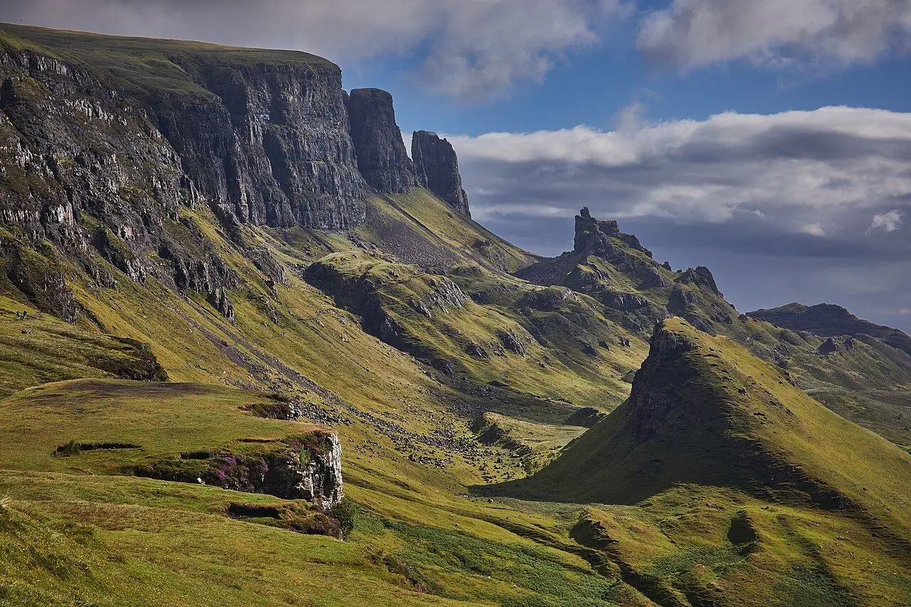
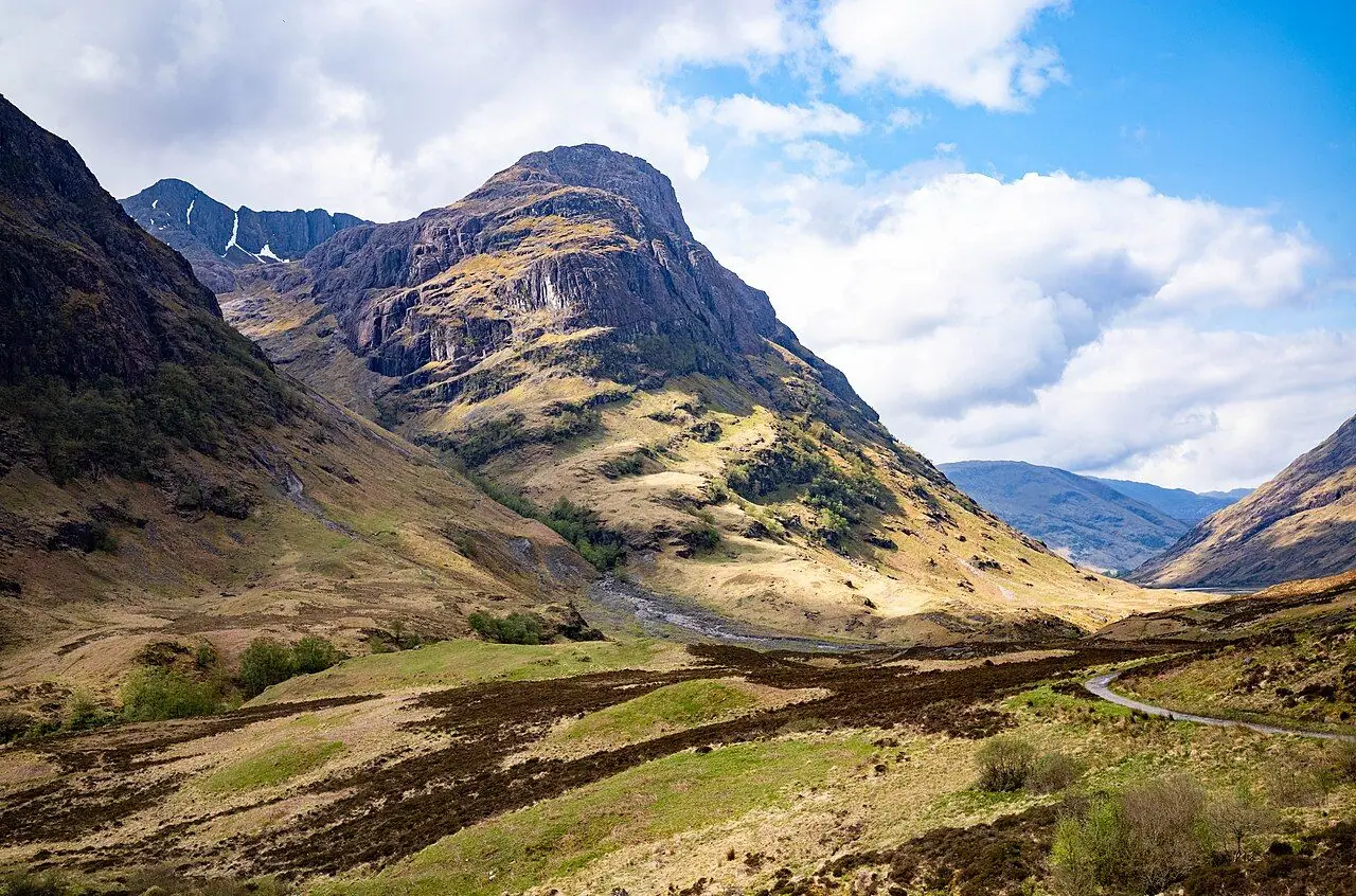
Have you ever seen a landscape that looks like a fantasy film set? The Quiraing is exactly that. At the northern end of Skye's Trotternish Ridge, a huge landslip has broken the edge of the escarpment into cliffs, pinnacles, hidden grassy plateaus and deep gullies. They all tumble down towards Staffin Bay and the sea. The rock formations have names like the Needle, the Prison and the Table, which already sounds exciting, doesn't it?
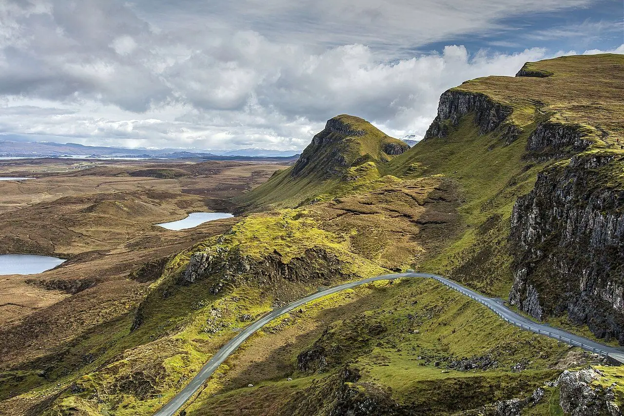
We explored lots of Skye on our road trip, from the Old Man of Storr to Neist Point, but we haven't hiked the Quiraing yet. It's high on our bucket list, so I've researched every detail for you. Here is a fun fact: thick layers of ancient lava sit on top of much weaker Jurassic sedimentary rocks. Over time the weight of the lava has made huge blocks break off and slide towards the sea. The Royal Geographical Society says it is the largest landslip in Britain. Parts of it are still moving, which is why the single-track road over the pass needs regular repairs.
I recommend doing the full Quiraing loop, rather than just walking the first stretch and turning back. You walk below the cliffs and pinnacles, then climb onto the escarpment and return along the top. From there you look straight down on the landscape you just walked through. At around 6.8 km it is a manageable half-day walk. However, it is rougher, steeper and more exposed to the weather than the distance suggests. In this guide I cover the loop, parking, buses and how to stay safe on the cliff path.
At a glance
- Distance: about 6.8 km for the classic loop (up to 8 km if you add the summit of Meall na Suiramach)
- Elevation gain: roughly 300–390 m, depending on the exact line
- Allow 2.5–3.5 hours including stops
- Difficulty: Moderate. A good path at first, then rough, rocky and narrow, with one short scrambly gully crossing and a steep grassy climb and descent
- Route type: Circular
- Start/finish: Quiraing car park at the top of the minor road between Staffin and Uig (Bealach Ollasgairte, grid ref NG 440 679)
- Best season: April–October. May, June and September often have the best balance of light and crowds
- Prices: no permit needed. Pay-and-display parking (Highland Council)
- Toilets: none at the start, and no café or water either. The nearest public toilets are at Staffin Community Hall
- Suitable for children: manageable for sure-footed older kids. Not pushchair-friendly
- Dogs: welcome on a lead, as sheep graze all over the area
Route description
You can walk the loop in either direction. I suggest going anticlockwise, along the lower path first and back over the top. This way you save the big views for the end, and you do the steep grassy descent last, when you can take it slowly.
Car park to the Prison
From the car park, cross the road and pick up the obvious path heading north along the base of the cliffs. This first section is the busiest part, as many visitors only walk a short way along it. The path is mostly level and well-trodden. On your right, steep ground drops away towards Staffin and the sea.
Early on you cross a stream in a rocky gully. This is the trickiest bit of the lower path. There is a short, awkward step across wet rock where you may need to use your hands. Take your time, especially if it has been raining.
Soon the Prison comes into view on your right. It is a huge, castle-like block of rock that has slid away from the main cliff.
The Needle and the Table
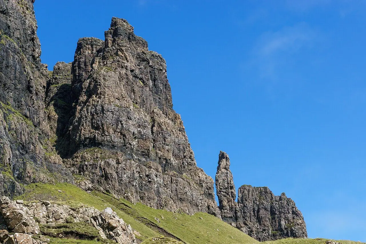
Further on, the Needle rises on your left. This jagged pinnacle is around 37 m (120 ft) tall. Behind it, a steep, loose path climbs up through the rocks towards the Table, a flat, grassy plateau hidden among the pinnacles. It is a popular detour. However, the ground is steep and eroded, so I would only do it if you are a confident walker and it is dry.
North to the head of the valley
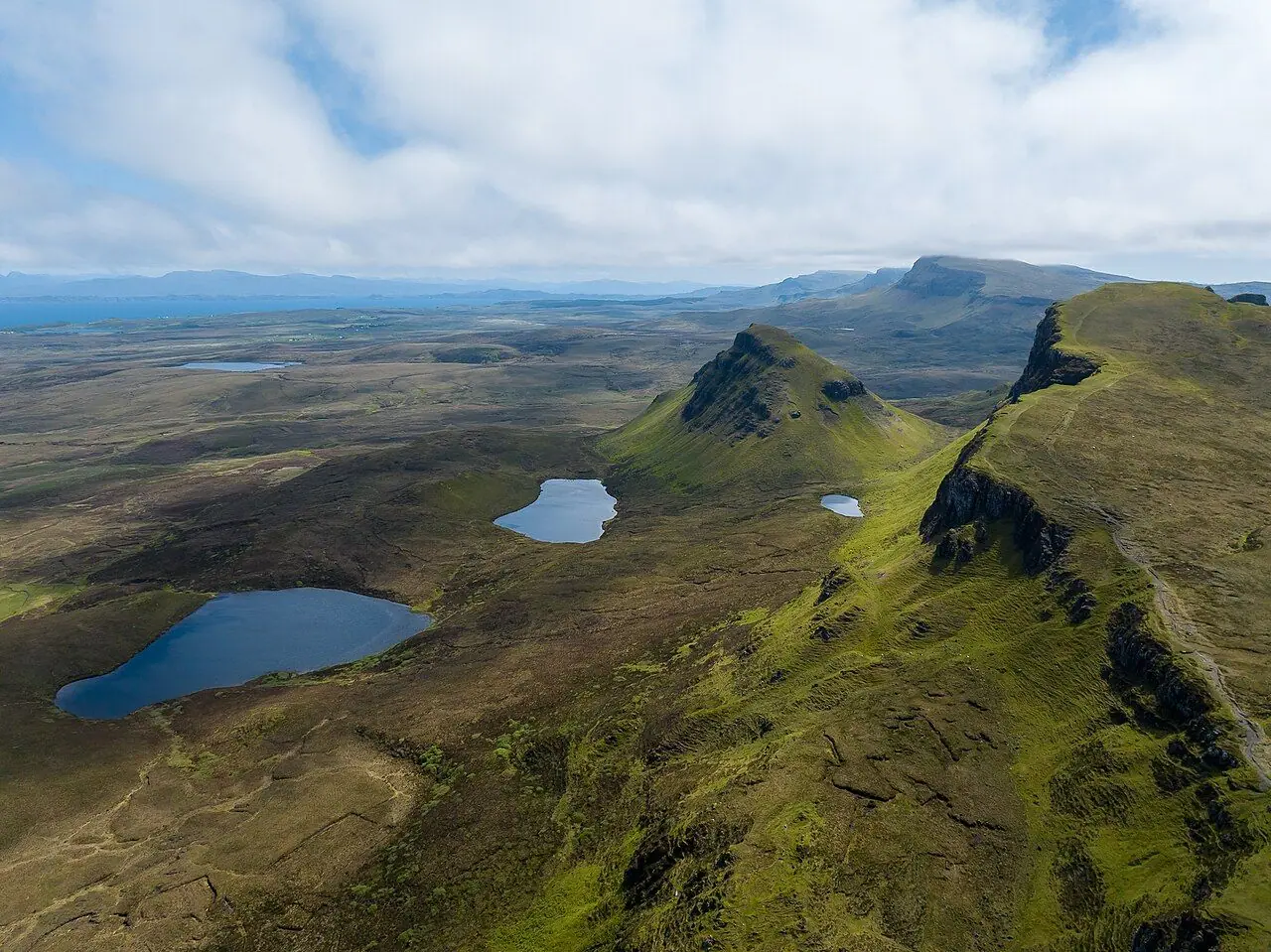
After the Needle there are far fewer people. The main path continues north below the cliffs, across open grassy slopes, with views over small lochans and down to the coast. The path is narrower here and can be boggy after rain. Towards the northern end of the cliffs, near an area called Fir Bhreugach, the path reaches a gap in the cliffs. Here you can climb onto the plateau.
Return along the escarpment
Head up the grassy slope through the gap onto the wide top of the escarpment. Then turn left (south) and follow the cliff edge back. This is where the walk gets really spectacular. You look straight down on the Table, the Needle and the Prison, with Staffin Bay and the mountains of the mainland beyond.
If you have time and energy, you can make a short detour west to the summit of Meall na Suiramach (543 m), the highest point of the area. The final part has no path and can be boggy. Otherwise, stay close to the cliff edge but sensibly back from it, as it is unfenced and sheer in places.
Descent to the car park
Finally the path starts to go down towards the road. It drops down a steep grassy slope and rejoins the road near the car park. This descent is slippery when wet, so walking poles help. Watch your footing all the way back to the road.
How to get there
By public transport
Unfortunately, there is no bus to the Quiraing car park itself. Stagecoach's 57A/57C circular service runs from Portree (Somerled Square) around the Trotternish peninsula via Staffin, Flodigarry and Uig. However, there are only a handful of journeys a day, Monday to Saturday, with gaps of two to three hours, and little or no Sunday service. The nearest stop is at Brogaig, Staffin. It is about 3 km from the start along the single-track road, and it is a steady climb.
So combining the bus with the walk means a long day. Allow time for the road walk up and back. Check the current Stagecoach timetable (or Traveline Scotland) carefully, so you don't miss the last bus back to Portree. To reach Skye without a car, take the train to Kyle of Lochalsh, or to Mallaig and then the ferry to Armadale. From there, Citylink or Stagecoach buses go to Portree.
By car and parking
From Portree, follow the A855 north for about 20 miles to Staffin. Then turn left onto the single-track road signposted for Uig and the Quiraing. The car park is at the top of the pass, about 2 miles up the road.
Parking: The car park is managed by The Highland Council, and the money goes back into path maintenance and local crofting. Charges apply daily from 8 am to 8 pm. At the time of writing they were £3 for up to 3 hours and £5 for up to 6 hours, with a 12-hour maximum stay. Check current tariffs on the Highland Council website. The car park fills early in summer, so aim to arrive before 9 am or later in the afternoon. Please never park in passing places on the single-track road!
Permits, fees & opening times
- You don't need a permit or entry fee to walk the Quiraing. It is open access land under the Scottish Outdoor Access Code.
- Parking is pay and display (Highland Council). See above.
- There are no facilities at the start. Staffin Community Hall has public toilets, and Staffin has a small shop. Check opening days, as some services don't open on Sundays.
When to go
You can do the walk all year, but April to October gives the best conditions and the longest days. In midsummer, the golden evening light on the pinnacles is stunning, and late afternoons can be quieter than mornings. Midges can be annoying from roughly June to August on still, damp days.
Skye's weather is famously changeable. Cloud often sits on the escarpment. This hides the views and makes it harder to find your way on the plateau. Strong winds are common too. They can funnel between the pinnacles and make the clifftop return feel exposed. If the top is in cloud or it is very windy, I suggest walking the lower path out to the Needle and back instead. In winter, snow and ice make the steep slopes and cliff edges really dangerous.
Hiking with kids
Suitable for children: The Quiraing is a brilliant adventure for older kids, as it really looks like a fantasy film set. However, it is not a buggy walk. The path is narrow, rocky and uneven from early on. There is a scrambly gully crossing, steep drops on the downhill side and unfenced cliffs on the return.
- Pushchairs: not suitable, even all-terrain models.
- Carriers: a back carrier works for the lower path to the Needle and back (around 2.5 km return). However, the steep grassy descent at the end of the full loop is awkward with a child on your back.
- Walking kids: sure-footed children of around 7 and up who are used to rough paths can manage the full loop with close supervision. Hold hands on the gully crossing and keep everyone well back from the edge on the clifftop.
To keep kids interested, challenge them to spot the Needle, the Prison and the Table. You can also tell them that the whole landscape is a slow-motion landslide that is still moving today. Then combine the walk with a hunt for dinosaur footprints at An Corran beach in Staffin (see below).
What to pack
- Walking boots with good grip, as the path is muddy and rocky
- Waterproof jacket and trousers plus a warm layer, even in summer
- Hat and gloves outside midsummer, as the plateau is exposed
- Midge repellent and a head net from June to August
- Water and snacks, because there is nothing at the car park
- Map (OS Explorer 408) and compass or offline GPS for the plateau in cloud
- Walking poles for the steep grassy descent
- Coins or a card for parking
Safety tips
- Keep well back from the cliff edges on the return. They are unfenced, sheer and sometimes undercut.
- Take the stream gully crossing slowly, especially when wet.
- Don't attempt the Table detour in wet weather, as the gully is steep and loose.
- Check the forecast. The Met Office and the Mountain Weather Information Service cover Skye. Turn back if the cloud drops or the wind picks up.
- Mobile signal is patchy. Tell someone your plans.
- In an emergency, call 999 and ask for Police, then Mountain Rescue.
Leave no trace & sustainable tips
- Stay on the main path. The Quiraing's popularity has caused serious erosion, and the soft ground scars quickly. Don't create new lines across the grass.
- Pay for parking. It funds path repairs and supports local crofters.
- Toilets: use the ones in Staffin or Portree before you go, as there are none on the route.
- No drones near livestock or other walkers, and keep dogs on leads around sheep.
- Take all litter home, including food scraps.
- Support the Staffin community. Buy supplies at the local shop, eat locally and choose locally owned accommodation on the Trotternish peninsula.
- If you come by car, think about car-sharing, and avoid peak hours to ease the pressure on the single-track road.
Where to stay & eat nearby
- Staffin has B&Bs, self-catering cottages and a campsite, plus a shop and a restaurant. Check opening days, as some places close on Sundays.
- Flodigarry Hotel, a few miles north, is a historic hotel with a restaurant and sea views.
- Uig, on the west side of the pass, has accommodation, places to eat and the ferry to the Outer Hebrides.
- Portree, Skye's main town, has the widest choice of hotels, guesthouses, hostels, cafés and restaurants. It is also the hub for bus services.
More to explore nearby
- An Corran beach, Staffin: look for Jurassic dinosaur footprints (around 170 million years old) on the sandstone ledges at low tide. Sand sometimes covers them in summer.
- Staffin Ecomuseum: a small museum with fossils, including a dinosaur leg bone.
- Kilt Rock and Mealt Falls: a short drive south of Staffin, with a viewing platform over the sea cliffs.
- The Old Man of Storr: Skye's other famous pinnacle walk, further south on the Trotternish Ridge.
- Duntulm Castle and the Skye Museum of Island Life at the northern tip of Trotternish.
FAQ
How long is the Quiraing walk? The classic Quiraing loop is about 6.8 km and takes most people 2.5–3.5 hours. A shorter out-and-back along the lower path to the Needle is around 2.5 km return.
Is the Quiraing walk difficult? It is moderate. The path is rough, rocky and narrow in places. There is a short scrambly stream gully, steep grassy slopes and unfenced cliffs on the return. So good boots and a reasonable level of fitness are essential.
Is there parking at the Quiraing? Yes, there is a Highland Council pay-and-display car park at the top of the pass between Staffin and Uig. It fills early in summer, so arrive before 9 am or later in the afternoon.
Can you get to the Quiraing by bus? Not directly. Stagecoach's 57A/57C from Portree stops at Brogaig, Staffin, about 3 km from the start. However, services are infrequent and don't usually run on Sundays. Check current timetables carefully.
Are there toilets at the Quiraing? No. The nearest public toilets are at Staffin Community Hall, so plan ahead.
Have you walked the Quiraing loop? Let me know in the comments!
Photo credits (4)
All photos on this page are by other photographers and are used under free licences. Thank you for sharing them.
- Cover photo: View towards the Quiraing.jpg by Thomas Fuhrmann, CC BY-SA 4.0, via Wikimedia Commons. Resized and cropped for this page.
- Photo 2: The Needle, Quiraing, Isle of Skye.jpg by Colin, CC BY-SA 4.0, via Wikimedia Commons. Resized for this page.
- Photo 3: Quiraing, Isle of Skye, Highland,.jpg by MPerkowski, CC BY-SA 4.0, via Wikimedia Commons. Resized for this page.
- Photo 4: The Quiraing, Trotternish Peninsula, Isle of Skye, The Inner Hebrides, Scotland.jpg by Thomas Andy Branson, CC BY-SA 4.0, via Wikimedia Commons. Resized for this page.


join the conversation
Comments
No comments yet. Be the first to share your thoughts!