🥾 Trail guide · Scotland – Highlands, Fort William
Ben Nevis Mountain Track: A Complete Guide to Climbing Britain's Highest Mountain

- Distance
- 16 km
- Ascent
- 1350 m
- Time
- 7–9 hours
- Difficulty
- Strenuous
- Route
- Out and back
- Best season
- June–September (snow can lie on the summit into early summer)
👶 With kids: Only for fit, experienced children around 10+ who are ready for a very long day in mountain weather. Not suitable for pushchairs, and I wouldn't take babies or toddlers to the summit.
✅ Updated and fact-checked on 5 November 2026. Prices, timetables and rules can change, so check the official sources before you go.
This post contains affiliate links. If you book or buy through them, I may earn a small commission at no extra cost to you. More about this
Have you ever wanted to stand on the highest point in the whole of the UK? Ben Nevis is 1,345 m high, and the most popular way up is the Mountain Track. Many people still call it the Pony Track or the Tourist Path. It starts almost at sea level in Glen Nevis, just outside Fort William, so you really do climb every single metre of the mountain.
Back in 2017 we spent two nights at the Glen Nevis campsite on our Highlands road trip. The start of the path was only a short walk away. However, the weather wasn't great, so we decided not to risk it and skipped the climb. It is still high on our bucket list, so I've researched every detail for you.
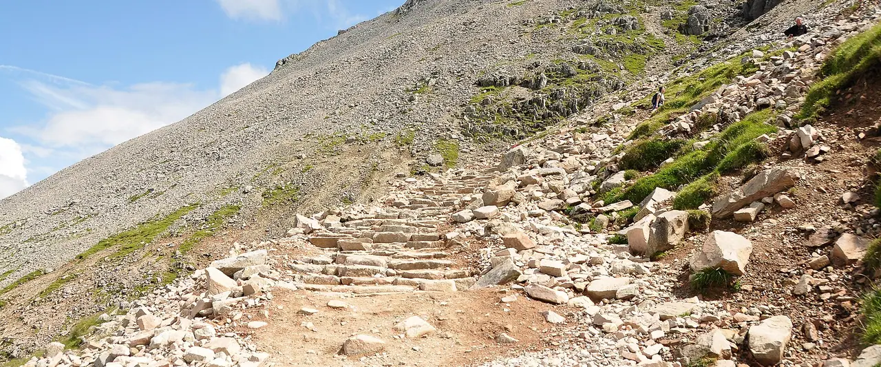
Don't let the word "tourist" fool you. The path is clear in good weather, but it is long, steep and rough. The summit plateau is surrounded by huge cliffs, and it is often in thick cloud even in summer. With the right kit, a good forecast and an early start, it is a really rewarding day out.
At a glance
- Distance: about 16 km (10 miles) return from the Ben Nevis Visitor Centre
- Elevation gain: around 1,340–1,360 m
- Allow 7–9 hours return. Most people take 3.5–4.5 hours to the summit
- Difficulty: Strenuous. It is a long, steep, stony path with no scrambling, but you need fitness and map and compass skills
- Route type: Out and back
- Start/finish: Ben Nevis Visitor Centre in Glen Nevis. You can also start from Achintee (Ben Nevis Inn) or Glen Nevis Youth Hostel
- Best season: June–September. Snow can lie on the summit until early summer
- Prices: free to walk, and no permit is needed. Parking at the Visitor Centre costs £8 per day
- Toilets: at the Visitor Centre during opening hours only. There are no toilets and no bins on the mountain
- Suitable for children: VisitScotland recommends it for children aged 10 and over
- Dogs: allowed on a lead. The sharp scree higher up can hurt their paws
Route description
Visitor Centre to the Youth Hostel path
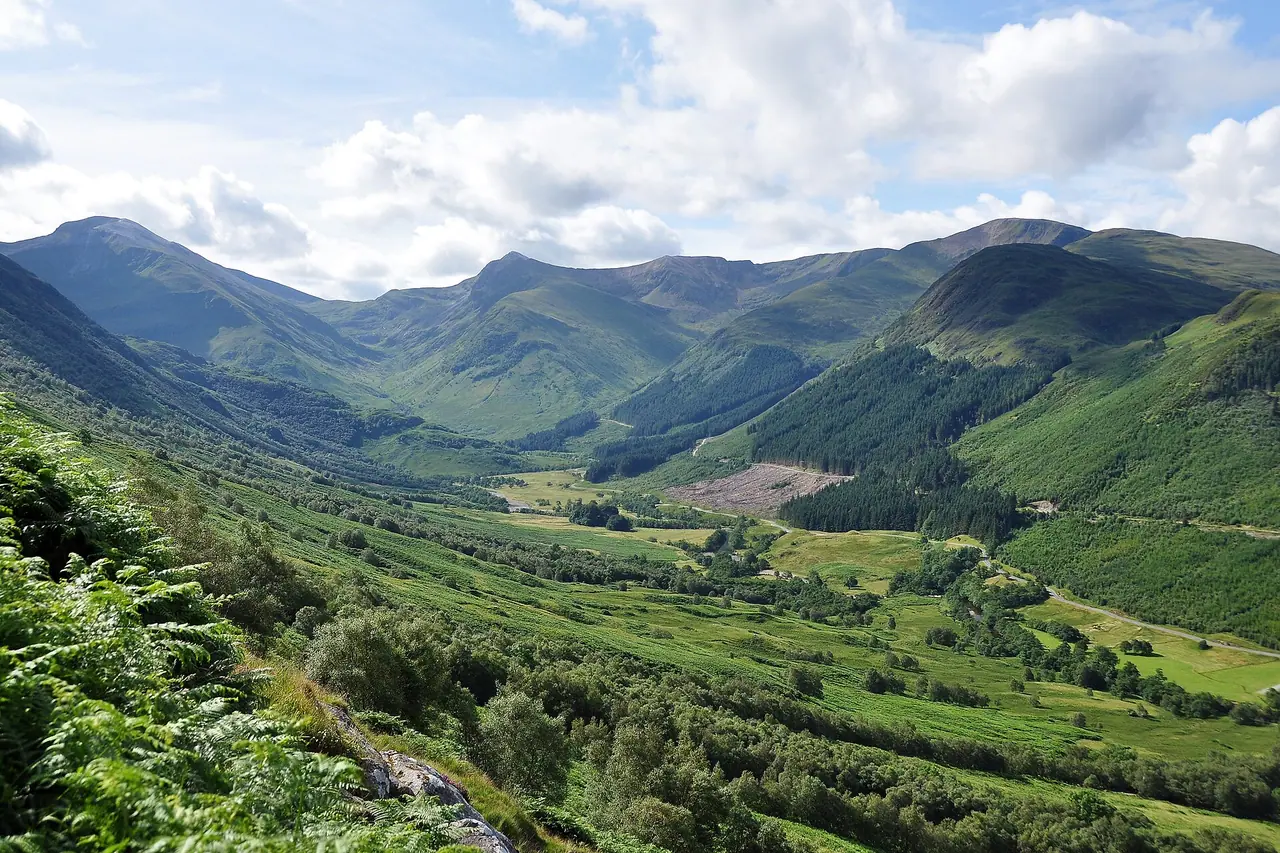
From the Visitor Centre car park, cross the footbridge over the River Nevis. Follow the path north beside the river and then towards Achintee and the Ben Nevis Inn. Here you turn uphill on the main track. It climbs at a steady angle across the slopes of Meall an t-Suidhe, with lovely views back down Glen Nevis.
After crossing a wall by a stile, the path from Glen Nevis Youth Hostel joins from the right. From here the track gets steeper and starts to zigzag. It climbs through scattered woodland and crosses two small metal footbridges over streams.
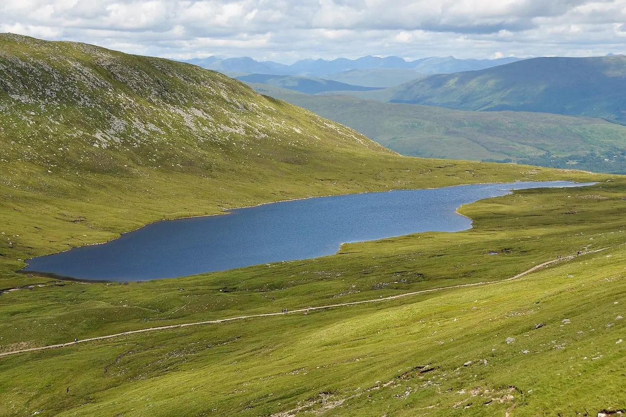
The Halfway Lochan
The path then turns into a wide, open corrie and zigzags up again. You climb above Lochan Meall an t-Suidhe, better known as the Halfway Lochan. It is a popular place to stop for a snack. However, it is not quite halfway in terms of effort, as the hardest climbing is still ahead!
Above the lochan you reach a path junction. The left fork heads towards the North Face and the Carn Mor Dearg Arête, which is only for experienced scramblers. Turn right for the Mountain Track.
Red Burn and the zigzags
Soon you cross the Red Burn. Take great care here if it is in spate after heavy rain. Then the real work begins. The path climbs the stony western slopes in a series of long zigzags. The ground gets rougher and more bouldery as you go up. It is tempting to cut the corners, but please don't. Shortcuts cause erosion, and the Red Burn area is known for people straying off the path.
Summit plateau
Higher up, the slope eases and you reach the broad, stony summit plateau. Large cairns mark the way to the top. Keep well away from the edge on your left. The huge cliffs of the North Face drop away here, and deep gullies such as Gardyloo Gully cut right into the plateau. In winter and spring, snow cornices can hang over these gullies, so never walk near the edge.
The summit
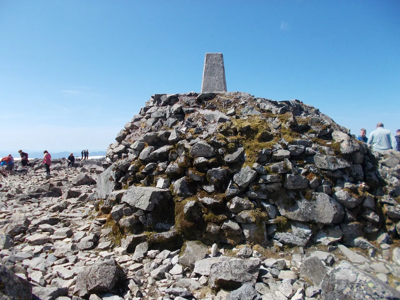
The summit is a rocky, often busy place. You will find the trig point on top of a big cairn, an emergency shelter and the ruins of the old weather observatory. The observatory was staffed from 1883 to 1904. The original pony track was built to supply it, and that is how the Mountain Track got its nickname. On a clear day the views over the Highlands are stunning. But don't be disappointed if you only see cloud. That is very normal up here!
The descent
You return the same way. In good visibility, just follow the cairns back to the top of the zigzags. In mist, getting off the summit is the most dangerous part of the whole walk. Head too far right and you reach the North Face cliffs. Head too far left and you can end up in Five Finger Gully, which is a known accident and avalanche spot. Mountaineering Scotland's advice is to walk from the trig point on a grid bearing of 231° for 150 m, then follow a grid bearing of 282° until you meet the track. Check the current magnetic variation before you go. The descent takes most people 3–4 hours and is hard on the knees.
How to get there
By car and parking
Fort William is about 2–3 hours' drive from Glasgow and 3–4 hours from Edinburgh. From the roundabout at the north end of town, turn into Glen Nevis. The Visitor Centre is about 1.5 miles up the glen road.
Parking: the Ben Nevis Visitor Centre car park has space for around 140 cars. High Life Highland, who run the centre, list parking at £8 per day, first come first served. You can pay by cash or card. It fills early in the morning in summer, so arrive early to avoid disappointment. There is more parking further up the glen, but please never park on the verges of the narrow glen road.
Public transport
- Train: ScotRail runs trains on the scenic West Highland Line from Glasgow Queen Street to Fort William. The average journey is just under 4 hours. The Caledonian Sleeper also runs from London Euston to Fort William, Sunday to Friday.
- Coach: Scottish Citylink coaches run from Glasgow Buchanan bus station to Fort William.
- Local bus: Shiel Buses run a limited summer service (N41) up Glen Nevis. Check the current timetable before you rely on it.
- On foot or by bike: it is about 1.5 miles from Fort William town centre to the Visitor Centre. There is a pavement along Glen Nevis Road, and you can cycle it too.
Permits, fees & opening times
- Permits: none needed. The upper mountain is owned by the John Muir Trust, and access is under the Scottish Outdoor Access Code.
- Groups: if you are in a group of 10 or more, register with the Ben Nevis Visitor Centre before you go.
- Ben Nevis Visitor Centre: open daily 8 am–4 pm (as of 2026). It has toilets, a shop with maps and outdoor gear, and hot and cold drinks and snacks. The daily mountain forecasts are on display.
- Toilets: the Visitor Centre toilets run on timers, so they are only open during centre opening hours.
When to go
In my opinion, June to September is the best time for most walkers. The days are long, and the path is usually clear of snow. However, the summit can still be below freezing on a sunny summer day, and snow is possible in any month. From late autumn to late spring, Ben Nevis is a serious winter mountain. You need an ice axe, crampons and the skills to use them.
Summer weekends and school holidays are really busy. On a busy day there can be over 1,000 people on the mountain. So start early on a weekday if you can. Avoid the first Saturday of September as well, when the Ben Nevis Race takes over the path.
Always check the MWIS forecast for the West Highlands and the Met Office mountain forecast before you set off. If the forecast is poor, turn back or choose a lower walk. We did exactly that, and I don't regret it.
Hiking with kids
Suitable for children: only for fit, experienced older kids. VisitScotland recommends the climb for children aged 10 and over, and they must be prepared for all weather. It is a very long day, so make sure they have done shorter mountain walks first.
- Pushchairs: not suitable at all.
- Carriers: I would not take a baby or toddler to the summit. The weather changes fast, and it can be very cold on top.
- Shorter options: walking up to the Halfway Lochan and back makes a great taster. For younger kids, I suggest the easy riverside paths in Glen Nevis or the walk to Steall Falls instead.
What to pack
- Sturdy walking boots with good grip
- A waterproof jacket and trousers, plus warm layers. Avoid cotton
- Hat, gloves and a spare warm top, as the summit is often much colder than the glen
- Map (OS Explorer 392 or the Harvey Ben Nevis map), compass and the skills to use them
- At least 2 litres of water per person on a sunny day, plus plenty of food
- A head torch and a whistle
- Walking poles. My knees started to hurt on our Highlands hikes, so I bought some poles in Fort William
- Sun cream and sunglasses in summer
Mobile signal is patchy on the mountain. So I also suggest carrying an emergency device. In my guide to emergency GPS devices, the Garmin inReach Mini is my pick for hiking. It lets you send an SOS and messages without phone signal.
If you are on a budget, the McMurdo FastFind 220 is a simple personal locator beacon. It is the budget pick in the same guide.
Safety tips
- Turn back if in doubt. The summit will still be there another day.
- Know the summit bearings and practise using your compass before you go. Cairns can be buried under snow.
- Keep away from the cliff edges and the gullies on the north side of the plateau, especially when there is snow.
- Tell someone your route and your expected return time.
- Take care crossing the Red Burn after heavy rain.
- In an emergency, call 999 and ask for Police, then Mountain Rescue.
Leave no trace & sustainable tips
- Take all your rubbish home, including banana skins and orange peel. There are no bins on the mountain.
- Stay on the path. Cutting the zigzags causes erosion, and volunteers spend a lot of time repairing it.
- Toilets: use the Visitor Centre before you set off. If you really need to go on the hill, go well away from paths and streams, and carry out paper and wipes.
- Keep dogs on a lead, as sheep graze on the lower slopes.
- Come by train or bus if you can. Fort William is well connected, and the car park fills fast.
Where to stay & eat nearby
- Glen Nevis Caravan & Camping Park: this is where we stayed. It is a really big campsite with plenty of space for tents and campervans. We had a hard-standing pitch, and there is a shop, washing-up area and laundry. The Ben Nevis path is a short walk away. They also have self-catering cottages further up the glen.
- Glen Nevis Youth Hostel sits right by one of the starting points, so it is great for an early start on a budget.
- Ben Nevis Inn at Achintee is a pub with a bunkhouse at the start of the path. It sounds like the perfect place for a well-earned dinner.
- Fort William has lots of hotels, B&Bs, supermarkets, cafés and outdoor shops. It is the obvious base for the whole area.
More to explore nearby
- Steall Falls: a lovely walk through the Nevis Gorge at the top of Glen Nevis to one of Scotland's highest waterfalls. It is in my list of the best waterfall hikes in the UK.
- Glenfinnan Viaduct: a must for Harry Potter fans. Arrive early to watch the Jacobite steam train cross the bridge.
- Glencoe: about 30 minutes' drive south, with the Lost Valley walk and stunning mountain scenery.
- Nevis Range: a mountain gondola on Aonach Mòr, next door to Ben Nevis.
FAQ
How long does it take to climb Ben Nevis?
Most people need 7–9 hours for the return trip on the Mountain Track. The climb to the summit usually takes 3.5–4.5 hours.
Is the Ben Nevis Mountain Track hard?
It is not technical, and there is no scrambling. However, it is long, steep and rough, with over 1,300 m of ascent. You need good fitness, proper kit and navigation skills for the summit plateau.
Do you need to pay to climb Ben Nevis?
No. Walking up is free, and you don't need a permit. You only pay for parking at the Visitor Centre, which was £8 per day as of 2026.
Can you climb Ben Nevis without a car?
Yes. Take the train or a Citylink coach to Fort William. Then walk about 1.5 miles up Glen Nevis Road to the Visitor Centre, or take the limited summer bus.
Have you climbed Ben Nevis? Did you get a view from the top? Let me know in the comments!
Photo credits (4)
All photos on this page are by other photographers and are used under free licences. Thank you for sharing them.
- Cover photo: Ben Nevis Mountain Track.jpg by Nilfanion, CC BY-SA 3.0, via Wikimedia Commons. Resized and cropped for this page.
- Photo 2: Lochan Meall an t-Suidhe.jpg by Nilfanion, CC BY-SA 3.0, via Wikimedia Commons. Resized for this page.
- Photo 3: The summit of Ben Nevis - geograph.org.uk - 7556873.jpg by Peter S, CC BY-SA 2.0, via Wikimedia Commons. Resized for this page.
- Photo 4: Glen Nevis from Ben Nevis track.jpg by Nilfanion, CC BY-SA 3.0, via Wikimedia Commons. Resized for this page.


join the conversation
Comments
No comments yet. Be the first to share your thoughts!