🥾 Trail guide · French Alps – Chamonix-Mont-Blanc
Lac Blanc Hike from La Flégère: A Complete Guide to Chamonix's Famous Mont Blanc Viewpoint

- Distance
- 7 km
- Ascent
- 500 m
- Time
- 3–3.5 hours
- Difficulty
- Moderate
- Route
- Out and back
- Best season
- July–mid-September (the Flégère gondola ran 20 June–13 September in 2026)
👶 With kids: Good for fit kids around 7+ who are used to mountain paths, or little ones in a back carrier. Not pushchair-friendly, and dogs are not allowed in the nature reserve.
✅ Updated and fact-checked on 5 November 2026. Prices, timetables and rules can change, so check the official sources before you go.
This post contains affiliate links. If you book or buy through them, I may earn a small commission at no extra cost to you. More about this
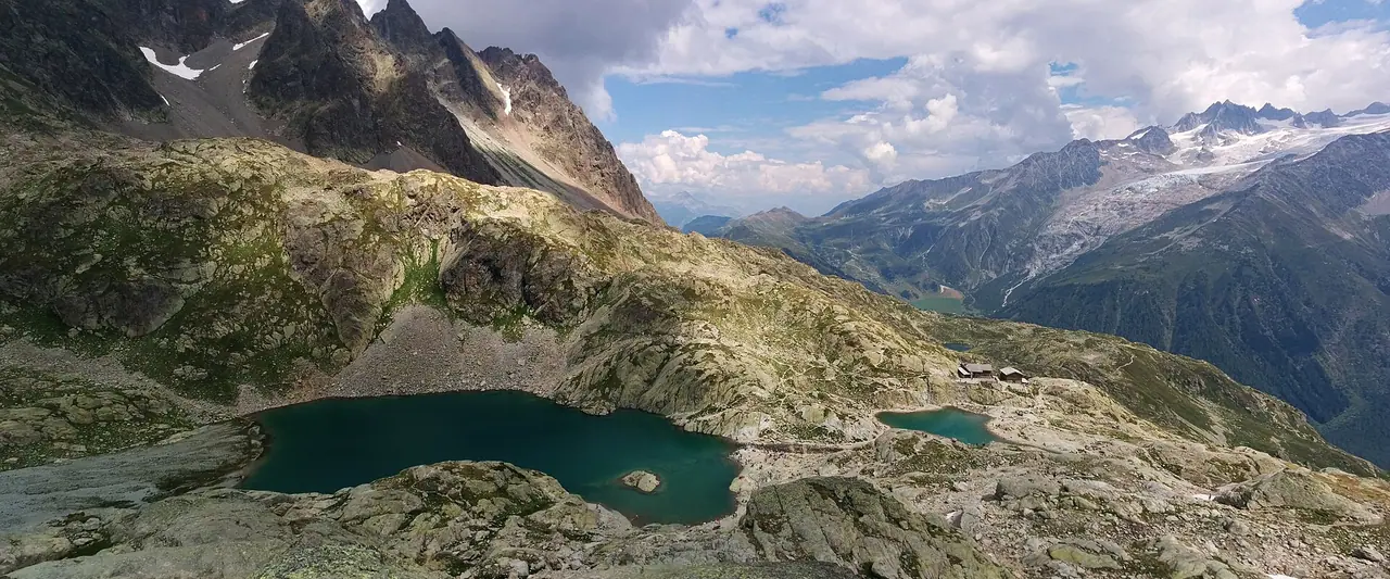
Have you ever seen a photo of Mont Blanc reflected in a still alpine lake? There is a good chance it was taken at Lac Blanc. This small lake sits at 2,352 m in the Aiguilles Rouges, on the sunny side of the Chamonix valley. From its shore you look straight across at Mont Blanc, the Aiguille Verte, the Grandes Jorasses and the Mer de Glace. It is one of the most famous views in the Alps, and in my opinion one of the best rewards for a half-day hike anywhere.
We haven't hiked this one yet, but it's high on our bucket list, so I've researched every detail for you. The easiest and most popular way up is from La Flégère. A gondola lifts you from Les Praz, just outside Chamonix, to 1,877 m. Then you walk up through the meadows, past a smaller lake, to Lac Blanc and its mountain refuge. You come back the same way.
However, it is a real mountain path. It is steep and rocky in places, and the tourist office even rates it as difficult. So good shoes, an early start and a bit of planning make a big difference. Below you will find the route, the 2026 lift times and prices, the buses and trains, and the nature reserve rules you need to know.
At a glance
- Distance: about 7 km return from the top of the Flégère gondola
- Elevation gain: around 500 m up and 500 m back down
- Allow about 1 hr 45 min up and 3–3.5 hours in total, plus time at the lake
- Difficulty: Moderate. The path is well used and easy to follow, but it is steep, stony and uneven in places. The Chamonix tourist office grades it as difficult because of the gradient
- Route type: Out and back
- Start/finish: La Flégère gondola top station (1,877 m), above Les Praz de Chamonix
- Highest point: Lac Blanc, 2,352 m
- Best season: July to mid-September, when the lift runs and the path is usually clear of snow
- Prices: the hike is free. In 2026 a return on the Flégère gondola cost €25 for adults and €21.30 for children aged 5–14. Under-5s ride free
- Toilets: there are none along the path, so go before you set off
- Suitable for children: yes, for fit kids who are used to mountain paths. Not suitable for pushchairs
- Dogs: not allowed. The trail is inside the Aiguilles Rouges nature reserve, where dogs are banned
Route description
Les Praz to La Flégère
The walk starts with a ride on the Flégère gondola from Les Praz de Chamonix. It replaced the old 1950s cable car in 2019, so it is fast and runs often. The gondola climbs over 800 m, which saves you a long and not very interesting climb through the forest. At the top station you are already at 1,877 m, with Mont Blanc right in front of you. It is a lovely spot for a first photo stop!
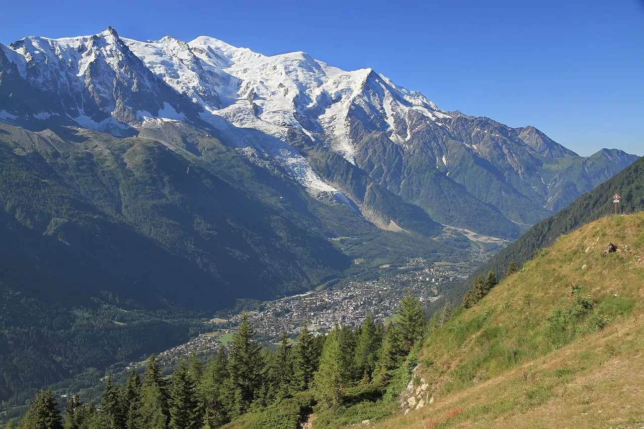
Combe de la Chavanne and Lac de la Flégère
From the top station, follow the signs for Lac Blanc. The path first drops a little into the Combe de la Chavanne, a wide grassy bowl. Near the old farm buildings, take the path on the left that climbs the slope. It passes the chalets and the small Lac de la Flégère at 2,027 m. This is a good place to catch your breath, as the steeper part is still to come.
The climb to Lac Blanc
Above Lac de la Flégère, the path continues up the mountainside along a ridge with another tiny lake. It then joins the path that comes up from Argentière. The last part climbs a rocky combe that gradually flattens out, and suddenly the lake appears in front of you. Take your time on this section. It is stony, and there are some big steps.
The views get better with every step. On your right you have the whole Mont Blanc massif, with glaciers spilling down towards the valley. I think this is the kind of hike where you will stop every five minutes for photos, so allow extra time!
Lac Blanc and the refuge
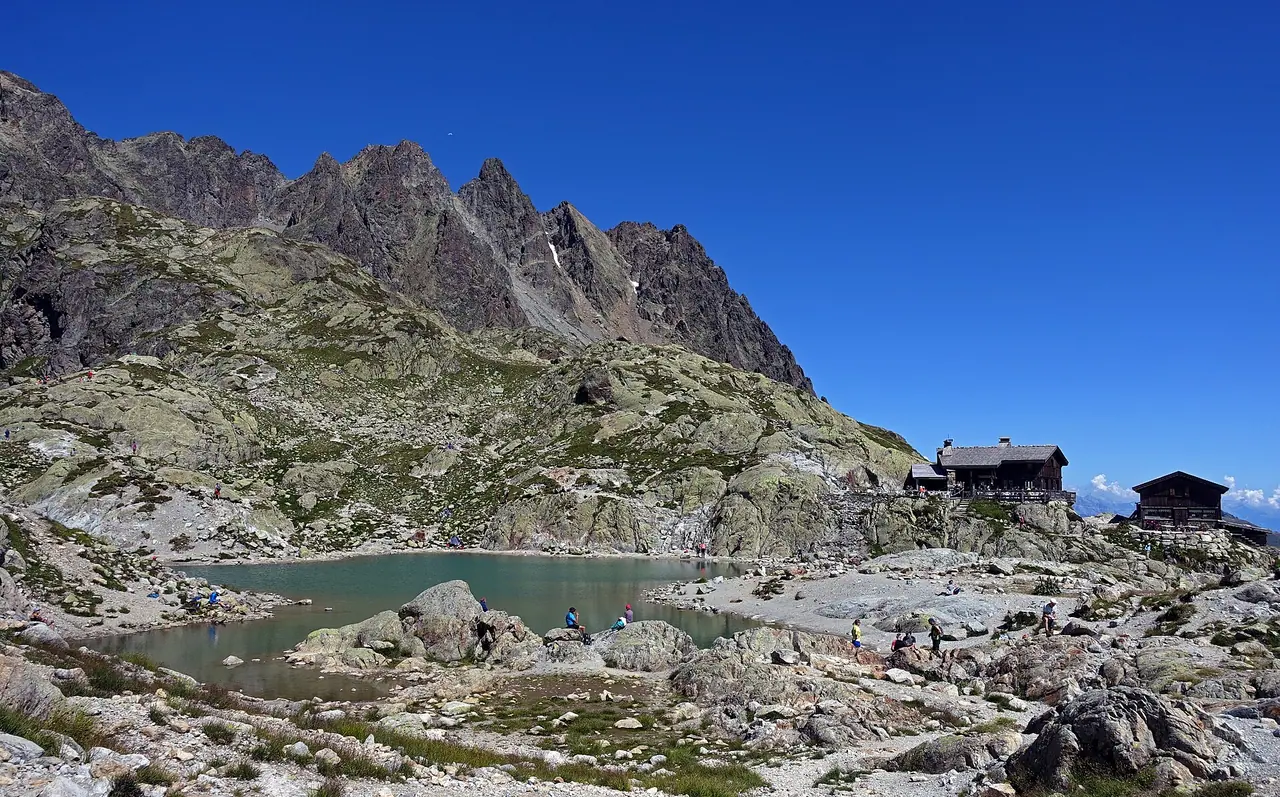
Lac Blanc is actually two small lakes, with the Refuge du Lac Blanc right next to the water. The water is cold and clear, and on a calm morning it mirrors the peaks across the valley. Find a flat rock, get out your picnic and enjoy it. The refuge serves drinks and food in summer, so you can also treat yourself to a hot chocolate or a slice of cake.
Please don't go for a swim, though. Swimming is banned in Lac Blanc and the Lacs des Chéserys by prefectural order, to protect these fragile high-altitude lakes.
Back to La Flégère
Return the same way to the gondola. Going down is quicker but harder on the knees, so walking poles really help here. Keep an eye on the time, as you need to be back before the last gondola down.
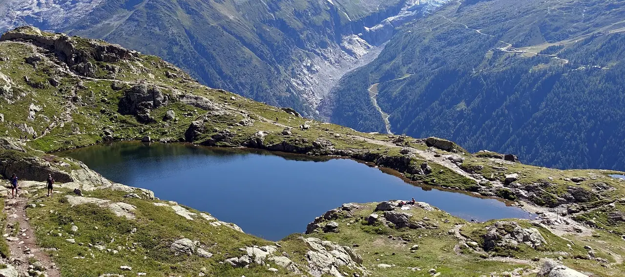
Extension: if you still have energy, you can walk down from Lac Blanc to the chalets and Lacs des Chéserys. They are pretty little lakes just below Lac Blanc. Remember that you need to climb back up afterwards!
How to get there
By car and parking
Les Praz de Chamonix is a small village about 2 km north of Chamonix town centre, on the road towards Argentière. The gondola leaves from the Flégère car park at 35 route des Tines.
Parking: the Flégère car park is free and open all year, according to the Haute-Savoie Mont-Blanc tourist board. In summer it is usually easier to find a space here than in winter. However, on sunny days in July and August I recommend arriving early.
By bus
The Chamonix valley buses stop at Les Praz Flégère, right by the lift. Line 1 runs between Les Houches, Chamonix and Les Praz. If you stay in the valley, ask your accommodation for the free guest card (carte d'hôte). It gives you free travel on the Mont-Blanc Express trains between Servoz and Vallorcine, and discounts of up to 50% on the valley buses (as of 2026). You can't buy it, as it comes with your stay.
By train
The Mont-Blanc Express (Saint-Gervais to Vallorcine) stops at Les Praz de Chamonix, about 4 minutes from Chamonix station. From the station it is a short walk to the lift. Trains run about once an hour, so check the times before you go.
Getting to Chamonix
Most international visitors fly into Geneva, then take a transfer or drive to Chamonix. By train, you change at Saint-Gervais-les-Bains-Le Fayet for the Mont-Blanc Express.
Permits, fees & opening times
- You don't need a permit or ticket to hike to Lac Blanc. Access is free.
- Flégère gondola 2026 season: 20 June to 13 September. It ran 8:35 am–5 pm until 10 July, 8:20 am–6 pm from 11 July to 30 August, and 8:35 am–5 pm from 31 August to 13 September. It was closed from 14 September to 27 November 2026 and reopens for the ski season. All times depend on the weather.
- Prices (2026): Les Praz–Flégère one way €19, return €25 for adults. Children aged 5–14 pay €21.30 return. Under-5s ride free. A return all the way to the Index chairlift (2,595 m) cost €43 for adults. The lift is also included in the Mont Blanc Multipass.
- Refuge du Lac Blanc: open in summer only, roughly June to late September. Sources give slightly different 2026 dates, so check with the refuge. It has around 40 beds and fills up fast, so book early if you want to stay the night.
- Nature reserve rules: the Aiguilles Rouges reserve was created in 1974. Dogs, camping, fires, music and picking flowers are not allowed. Swimming is banned in Lac Blanc and the Lacs des Chéserys. Bivouacking near Lac Blanc is banned in summer, and elsewhere in the reserve you need to book a spot online.
When to go
The best time is July to mid-September. The gondola usually opens in late June, but snow can stay on the upper path until early July. The Chamonix tourist office lists the trail from 1 July to 30 September, depending on conditions. In 2026 the gondola stopped on 13 September, so a September hike means walking up from the valley later in the month.
July and August are the busiest months. Lac Blanc is extremely popular, so I suggest taking one of the first gondolas. You beat the crowds and the heat, and the light on Mont Blanc is beautiful in the morning. Also, afternoon thunderstorms are common in summer. Always check the mountain forecast the evening before, and turn back if clouds start building.
Hiking with kids
Suitable for children: yes, for kids who are already used to proper mountain hikes. The distance is short, but 500 m of climbing on a stony path is a lot for little legs. I think children from around 7 or 8 who walk regularly will enjoy it most. The lake and the refuge at the top make a great goal.
- Pushchairs: not suitable at all. The path is rocky and steep.
- Carriers: a back carrier works for toddlers, but take extra care on the descent and the big rocky steps.
- Shorter option: walk to Lac de la Flégère at 2,027 m instead. It is a much shorter climb and still has lovely views.
- Keep it fun: look out for marmots and ibex, count the glaciers on Mont Blanc and promise a hot chocolate at the refuge.
- Remember: no dogs and no paddling in the lake, so explain the rules to kids before you set off.
What to pack
- Hiking boots with good grip, as the path is stony and uneven
- Walking poles for the descent
- A warm layer and a waterproof jacket. It is much colder at 2,352 m than in Chamonix
- Sun cream, sunglasses and a hat, as there is no shade above the tree line
- At least 1.5 litres of water per person
- A picnic and some cash or a card for the refuge
- Your lift ticket and the time of the last gondola down
Mountain air always makes me hungry, so I never go up without plenty of snacks. Nuts, dried fruit and energy bars are perfect for a quick boost on the steep bits. I share more ideas in my guide to the best food for expeditions.
Safety tips
- Start early and check the weather. Summer storms build quickly in the afternoon, and you don't want to be on an exposed slope in a thunderstorm.
- Watch out for snow early in the season. Old snow patches can be hard and slippery, especially in the morning.
- Take it slowly on the way down. Most slips happen on the descent, when legs are tired.
- Know the last lift. If you miss it, you face a long, steep walk down through the forest.
- Get advice from the Chamonix tourist office or the Office de Haute-Montagne if you are unsure about conditions.
- In an emergency, call 112.
Leave no trace & sustainable tips
- Follow the reserve rules. No dogs, no fires, no music, no flower picking and no swimming in the lakes. They are there to protect a very fragile environment.
- Stay on the path. Thousands of people walk here every summer, and short cuts damage the alpine plants.
- Take all your rubbish home, including fruit peel and tissues.
- Leave the car at home. With the guest card, the buses and the Mont-Blanc Express are free, and they stop right at the lift.
- No drones. Flying over the reserve is prohibited.
- Support the refuge. Buying a drink or a meal there helps keep this lovely place running.
Where to stay & eat nearby
- Chamonix is the obvious base, with hotels, apartments, hostels and campsites, plus lots of restaurants and supermarkets for picnic supplies.
- Les Praz de Chamonix is quieter and right next to the gondola. It is a good choice if you want to be first in the queue in the morning.
- Argentière, further up the valley, is smaller and cheaper than Chamonix, and it is on the bus and train line.
- Refuge du Lac Blanc: for a really special experience, spend a night at the lake. Watching sunset and sunrise on Mont Blanc from here must be magical. Book well in advance.
More to explore nearby
- Index chairlift: continue from La Flégère to 2,595 m for even bigger views of the Mont Blanc massif.
- Lacs des Chéserys: a short extension from Lac Blanc to a chain of little lakes.
- Col des Montets: the nature reserve's visitor centre is here, with a nature trail and exhibitions. It is great for kids.
- Aiguille du Midi: the famous cable car to 3,842 m, right in the heart of the Mont Blanc massif.
- Montenvers and the Mer de Glace: a cog railway to France's biggest glacier.
FAQ
How long is the Lac Blanc hike from La Flégère?
It is about 7 km return with around 500 m of climbing. Allow about 1 hr 45 min up and 3–3.5 hours in total, plus time at the lake.
Is the Lac Blanc hike difficult?
It is not technical, but it is steep and stony in places. The Chamonix tourist office grades it as difficult. Anyone with good shoes and reasonable fitness can do it, but take your time.
Can I bring my dog to Lac Blanc?
No. The trail is in the Aiguilles Rouges nature reserve, where dogs are not allowed. Dogs on a lead can ride the Flégère gondola, but they can't go into the reserve.
Can you swim in Lac Blanc?
No. Swimming is banned in Lac Blanc and the Lacs des Chéserys to protect the lakes.
Have you hiked to Lac Blanc? Did you see Mont Blanc reflected in the lake? Let me know in the comments!
Photo credits (4)
All photos on this page are by other photographers and are used under free licences. Thank you for sharing them.
- Cover photo: Lac Blanc Chamonix PANO 20180821 133833.jpg by Ermakae, CC0, via Wikimedia Commons. Resized and cropped for this page.
- Photo 2: Chamonix valley from la Flégère,2010 07.JPG by Ximonic, Simo Räsänen, CC BY-SA 3.0, via Wikimedia Commons. Resized for this page.
- Photo 3: Lac Blanc and refuge.jpg by Tiia Monto, CC BY-SA 3.0, via Wikimedia Commons. Resized for this page.
- Photo 4: Lacs des Chéserys 3.jpg by Tiia Monto, CC BY-SA 3.0, via Wikimedia Commons. Resized for this page.


join the conversation
Comments
No comments yet. Be the first to share your thoughts!